|
|
Joyce's Search Tip - December 2007 -
 |
Do You Know that you can search just this
Bradsby book by using the Bradsby button in the Partitioned search
engine at the bottom of the Current
What's New Page? |
|
|
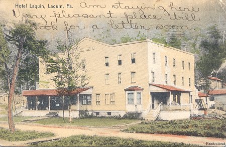
GEOGRAPHICALLY, the township of Barclay is situated between the townships
of Franklin on the north, Le Roy on the west, and the Schraeder branch
of Towanda creek, which separates it from Overton on the south, and whatever
of eastern boundary it has is Monroe. Topographically, it is mountainous;
the Schraeder branch of the Towanda creek bein -its only stream of water.
Geologically. it is coal-bearing, being essentially and specifically a
mining town. Historically, it is a recent organization, being formed from
Franklin in 1867. Its entire area is owned by the coal mining and Barclay
Railroad companies, and it is said that it has not within its limits a
solitary resident freeholder. Its chief interest lies in its coal mines
and their development, which are fully described in the general history
of the county
The first settlement, or movement, therefor, in the township was made
in the fall of 1856, by the Towanda Coal Company. There are at the present
time five settlements in the town, tile most northern one called Graydon,
next South Dublin, Barclay postoffice still further south, Fall Creek a
little way east of the postoffice, and a settlement at the foot of the
incline of the railroad.
Graydon has a school-house and store; at Barclay there are a postoffice,
a Presbyterian church, a school-house, stores, the works of the Towanda
Coal Company, and freight and engine houses of the Barclay Railroad Company.
At Fall Creek there are a school-house and store, and in the settlement
at the foot of the incline there is a school-house. -Foot of Plane is a
station on the Barclay Railroad.
Coal was discovered in the Barclay mountains by Edsal Carr, who supposed
be had found iron. Jared Leavenworth was the first blacksmith to use the
coal, which was first brought down the mountain side on sleds. John Fox,
father of Miller Fox, hauled the first load to Towanda.
The preceding was scanned from the Bradsby book and interpreted
by OCR software by Joyce's office staff. It was edited and formatted by
Joyce M. Tice. Financing for this project was provided by the gift contributions
of web site guests who are listed on the sponsors
page. Our gratitude goes out to them for helping to cover some of the costs
of generating this web site.
You are the visitor
since the counter was installed on December 25, 1998
Joyce Tip Box -- December 2007 -
 |
If you are not navigating this Tri-Counties
Site via the left and right sidebars of the Current
What's New page you are doing yourself a disservice. You can get
to any place on the site easily by making yourself familiar with these
subject and place topics. Try them all to be as familiar with the site's
16,000 plus pages as you can. Stop groping in the dark and take the lighted
path. That's also the only way you'll find the search engines for the site
or have access to the necessary messages I may leave for you. Make
it easy on yourself. |
|