Tri-Counties Genealogy &
History by Joyce M. Tice
 |
Indian Trails |
|
 |
|
Bradford County PA
|
Chemung County NY
|
Tioga County PA
|
|

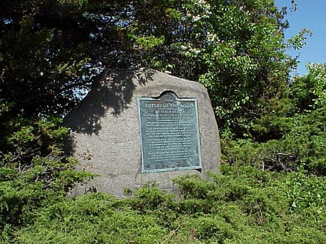
This marker on Route 20 in New York State records the road's history
from its origin as an Indian Trail |
| Article: Indian Trails |
|
Article by Helen Mac Dougall Samson (1909-1995)
in 1976
Sent in by Walt Samson |
Retyped by Bob Saftenberg
Photo by Joyce M. Tice 1999 |
|
|
|
Joyce's Search Tip - November 2008
 |
Do You Know that you can search just the
articles on the site by using the Articles button in the Partitioned search engine at
the bottom of the Current What's New
Page? |
|
|
Our Heritage of Freedom
Indian Trails
By Helen M. Samson
When the earliest settlers arrived in this area, the methods of travel
available to them was very limited. Their selections were reduced to travel
by river, or the use of the Indian trails that crisscrossed the area connecting
tribal settlements many miles apart.
The most used trail in this part of the state may have been Catherine’s
Town or Seneca Lake Trail. Early maps indicated this route followed Catherine
Creek south, midway between the town of Horseheads and Veteran. One branch
turned sharply west toward the town of Assinesink near Corning, while the
other branch proceeded south to the Chemung River.
Middle Road follows this old trail for a distance, after which the path
went over the hills to avoid the swamps.
A lesser known trail in this area was Pony Hollow. One branch connected
with the Catherine’s Trail and another section came from Cayuga Inlet.
These two joined and turned directly south. The Pony Hollow path is in
part the present day main road to Ithaca.
This trail was used by Co. William Butler’s 600 man expeditionary force
in 1779, sent to attach the Six Indian Nations, allies of the British during
the revolution.
The Forbidden Path ranged from Binghamton to the Indian settlement of
Genesee, and traveled west along the Alleghany River. It crisscrossed present
day state lines and finally died in the town of Jenushadego.
This great network of large and small paths were used by the settlers
to the fullest advantage. As westward expansion increased, travel blossomed
and these old paths were eventually widened and straightened, and today
constitute a part of our highway system.
The young moccasined braves that blazed these early trails had given
way to loaded oxcarts, with families and starry eyed children, heading
west to make a new life for themselves.
The settlers learned much from his predecessor, the not so simple child
of the forest.

|
First Added to the Site on 30 DEC 2002
By Joyce M. Tice
Email: JoyceTice@aol.com

You are the
visitor since the counter was installed on 30 DEC 2002 |

